2/25/2021
Charlotte County, where Nisani Farm resides, was established 1714 and is full of white human significance.
In 1776 charlotte county voted for independence during the Revolutionary War and French troops stationed at what is now Charlotte Court House (p. 23), only 15 min away from Nisani Farm.
Several important historical figures and places resided in Charlotte County or close to Nisani Farm, including Patrick Henry, one of the founding fathers lived on Red Hill, a property around 10 min from Nisani Farm (Give me liberty or give me death!). Appomattox Courthouse, only 30 min away from the farm was where Robert E Lee surrendered to Ulysses S Grant, ending the civil war in 1865.
Charlotte county was known for antebellum homes and a large slave population to cultivate millions of pounds of mainly tobacco, which Charlotte County produced more than twice as many bushels of corn, wheat and oats. From 1790-1830 the total population in Charlotte County doubled yet the white population stayed the same. The slave population however doubled from 4,816 to 9,433 leaving a 2:1 ratio of slaves to whites (Priddy 29, As cited in the Historic Architectural Survey of Charlotte County Virginia).
After learning all of this information I was curious about exactly what Nisani Farm was used for, or who it was owned by a few hundreds of years ago.
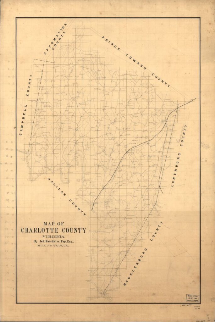
I found two different maps using the Library of Congress, both from 1865. To find who owned the farm during that period I referenced google maps and the designated border of Charlotte County as well as several landmarks. I specifically used the landmark of Cub Creek which appeared on every map making it easy to spot the general area that the farm resides. According to the first map, Maj Pendelborn was the owner of the property although the writing was incredibly hard to read and the google search turned up nothing.

The second map published in the 1860’s named Gaines’ as the owner of the property. When googling him it turns out Maj William Gaines could be who the first map was talking about. It was difficult finding a reputable source but from what I found Major Gaines was a wealthy plantation owner who owned at least a hundred slaves. I also was able to see that he sent two letters in 1863 about Charlotte County Virginia yet was unable to get access to the letter so that I could read them.
“Letter, 17 July 1863, from R. J. Gaines of Charlotte County to Sallie [Sarah] Gaines regarding her living near the enemy and the losses Confederate armies have suffered.
Letter, 1 September 1863, from R. J. Gaines to William Gaines informing William that there is a place for rent in Charlotte County and providing some family news”
I was afraid to start delving into the history of the farm, not sure how I would feel when I found out for sure that our property was owned by a slave holder, which is in fact was. Instead of feeling sad, I feel proud of what this land has become. A black, woman-owned farm where we find preservation of nature and sustainability important is a drastically good change from what the property was used for before. I am excited to do more research about the Gaines family and the slaves he owned so as to possibly track descendants.
- Bennett, Karen M. “Maj William C. Gaines (1767-1850) – Find A Grave…” Find a Grave, 9 Aug. 2013, www.findagrave.com/memorial/115174744/william-c_-gaines#source.
- Hotchkiss, Jedediah. “Map of Charlotte County, Virginia.” Library of Congress Geography and Map Division Washington, D.C, 186AD, www.loc.gov/resource/g3883c.cwh00289/.
- Cassell, Charles, et al. “Map of Charlotte County, Va.” Library of Congress, Virginia : Chief Engineer’s Office D.N.V., 1864. Cadastral Maps, hdl.loc.gov/loc.gmd/g3883c.la001236.
- History.com Editors. “Battle of Appomattox Court House.” History.com, A&E Television Networks, 9 Nov. 2009, www.history.com/topics/american-civil-war/appomattox-court-house.
- Blanton, Alison, et al. “HISTORIC ARCHITECTURAL SURVEY OF CHARLOTTE COUNTY, VIRGINIA.” Charlotte County, June 1998, pp. 1–161., www.charlotteva.com/pdfs/historic_survey.pdf.
This is excellent historical information. And the maps are such a great addition!